Where do you live?
Locals in a large swath of the East Bronx —north of Pelham Parkway, east of Bronx Park East and south of East Gun Hill Road — have been unsure how to answer that simple question for generations.
Community Board 11 hopes to straighten the issue out by working with the City Department of Planning to ax the outdated names “Bronxdale” and “Laconia” from the city map. In their place would be a new neighborhood: “Allerton,” bordered by approximately Waring Avenue, Bronx Park East and East Gun Hill Road.
Outdated names
City Planning’s current community map labels a small slice of the area above Pelham Parkway and west of Pelham Gardens as “Bronxdale,” and an area north of that “Laconia.”
But locals say they have never heard anyone use those nabe names to describe where they live.
“There’s no question that those names are not accurate,” said Jeremy Warneke, CB11’s district manager. “No one calls that area Bronxdale. Find me one person who calls that area Bronxdale.”
It’s hard to find anyone with a clear idea of where “Bronxdale” or “Laconia” begin or end.
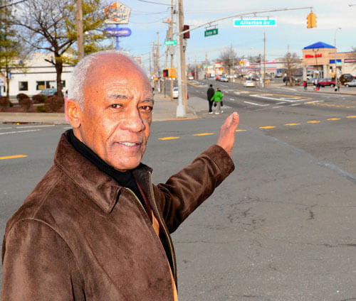
“You tell people you’re from Bronxdale and they have no idea where you are from,” said Joe Thompson, president of the 49th Precinct Community Council, who has lived in what he calls the “Allerton Avenue area” for nearly 50 years.
Urbanized Overnigh
t
The nabe naming problem stems from the borough’s rapid transformation from farmland to urban sprawl in the early part of the 20th century, said official Borough Historian Lloyd Ultan.
Early maps label a village of Bronxdale on the west bank of the Bronx River at Boston Road —today a parking lot for the Bronx Zoo.
What is now Bronxdale Avenue was originally called “Bear Swamp Road” because it ran northwest from what is today Morris Park to the Bronxdale village, according to documents from the East Bronx History Forum.
Labeling anything above Pelham Parkway “Bronxdale” has no historical basis, and was probably a mistake, Ultan said.
Laconia on the other hand was a real-estate development built in the 1880s, and named after an area in Greece whose capital is Sparta.
With the building of train lines and highways, the east Bronx’s character fundamentally changed —so quickly that developers did not have time to create solid neighborhood lines.
Today, Allerton Avenue —named after Mayflower passenger Issac Allerton, — is the area’s main commercial strip, used to help define the nabe.
“You say I live near Allerton Avenue,” said Thompson, “and people can identify it and know where it is.”
Nabe identity
But just labeling an area by its street name does not build the sense of identity that Allerton locals want.
Fluid boundaries also can cause confusion in the real estate business. Sonny Vitaj of Exit Realty Power says he solves this problem by calling the entire area the “Allerton Avenue corridor.”
Solutions
City Planning is open to the name change, since the neighborhood boundaries on its map are already unofficial, said a department spokesman.
Historian Ultan cautioned that re-naming any neighborhood would be “creating a fiction, something that does not exist and never has existed.”
But locals say drawing arbitrary boundaries is a worthwhile price to pay to boost nabe pride.
“People would like to see where they live properly identifed,” said Thompson.