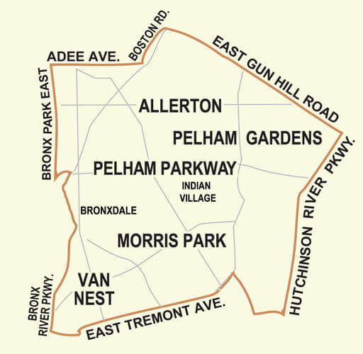
Allerton is definitely on the city map —but now the fate of Bronxdale is up for debate.
As an east Bronx Community Board hashes out the final details of its quest to define itself with the city Department of Planning, both sides are grappling over whether the outdated but historic name ‘Bronxdale’ should stay.
“It’s supposed to be a topical map, so I don’t see why we need the historic name,” said Jeremy Warneke, the district manager at Community Board 11, which includes Morris Park, Van Nest, Pelham Parkway, Pelham Gardens, and —well there’s the rub.
Historical headache
The board has campaigned with the city to change its nabe maps since January, when Warneke noticed that City Planning’s names for his district were far off what anyone who actually lived there called their stomping grounds.
Planning’s maps listed a ‘Laconia’ just south of E. Gun Hill Road, along with a ‘Bronxdale’ above Pelham Parkway and just east of Bronx Park East.
After a push from local elected officials, City Planning agreed to change its maps with input from the community board.
During the ensuing back and forth exchange, the process has essentially replaced ‘Bronxdale’ with ‘Allerton,’ a new neighborhood that revolves around the Allerton Avenue commercial strip.
But City Planning does not want to get rid of the name ‘Bronxdale’ entirely. The name refers to a cotton farming village built in the 1880s on the east bank of the Bronx River at Boston Road, according to documents provided by the East Bronx History Forum.
Today the former home of Bronxdale is a parking lot for the Bronx Zoo. And one would be hard-pressed to find any one who still uses the name.
“You tell people you’re from Bronxdale and they have no idea where you are from,”Joe Thompson, the 49th Precinct Community Council president, told the Times-Reporter in January.
But City Planning wants to keep the name on the map and move it to its proper historic location, south of Pelham Parkway.
“After doing some research we found that there is some historical significance to the neighborhood of Bronxdale and we repositioned it on the map to accurately reflect its original location,” Marlon Anderson, an associate city planner, emailed Warneke.
In City Planning’s most recent map draft, obtained by the Times-Reporter, the two parties seem to be nearing a compromise. Bronxdale has been shifted below Pelham Parkway and is drawn in a smaller font.
Warneke says he’d like to see at least some sort of historical asterik next to the name, if Bronxdale must stay on.
The full community board is scheduled to vote on the new nabe map at an upcoming meeting.